A version of this blog also appears this week in the Middleteon Times Tribune.
This particular trek actually celebrates my brother Bill’s 60th birthday and builds on five decades of shared hiking history. Fifty years ago, we climbed “The Whites” as summer-long campers in NH (alas, no surviving photos from that memoralbe era). This decade, we decide to go light—without 60 pounds of tent, tarp, sleeping gear, stove or much food—and hike “hut to hut,” letting college crews serve us B & B style instead. That’s the plan anyway, as we seek to reprise youthful adventures and renew dreams of hiking the AT, section by section, in our retirement years. But this 2011 adventure would put an end to such dreams.
After weeks of local workouts, REI purchases, library and on-line research—and with last year’s climb up four 14,000-foot peaks in Colorado as a recent confidence boost—I’m ready. I’ll bag several 4,000- and 5000-foot peaks in no time, or so I think. After all, what could these “smaller” mountains throw my way that I couldn’t catch? Plenty, as it turns out.
Mt Madison via the Osgood Trail is a steep, treacherous and unrelenting ascent, bringing us fitfully from 2400 to almost 5000 feet. This trail salutes “no gain without pain.” I was soon puffing like a steam engine, with Bill dieseling behind wondering if we’re still on track. The station stops for water breaks start out 30 minutes apart, then 20, 15, 12, then 8. The lead engine (me) flags to stop; I wonder if this is it.
Remembering how freight trains link engines to generate more power and traction to gain altitude, Bill begins pushing my backpack up with every upward step I take. Together, we find new pace and lifted spirits. With a changed attitude (“I think I can, I think I can, I think I can…”) and the hikers’ prayer (that I would renew my hope and strength and not stumble and fall; see Isaiah 40:30-31), we chug ahead and gain the necessary altitude. We clear tree line at 4500 feet, only to be buffeted by wind gusts (40+ mph?) and plunging temperatures (40 degrees?) on the exposed ridgeline. Winter outerwear and new tactics (crawling, scrambling) are immediately deployed. Nothing but a menacing mile-and-a-half obstacle course of huge wet boulders stands between us and a warm 5-course dinner at Madison Hut.
“All’s well that ends well,” we say, but this first leg of a projected 6-day, 5-night, 50-mile trip has only just begun. It would end the next day, abruptly, one hour into our climb.
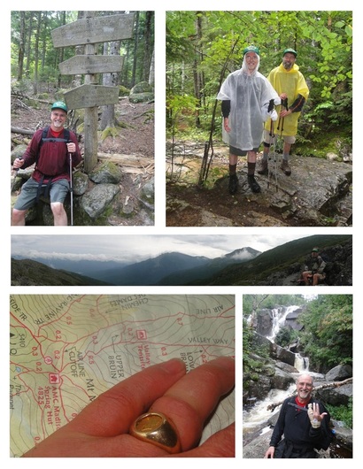
At Thunderstorm Junction—5500 feet up, where numerous trails converge granting trekkers access to Mt Washington and beyond—my legs slip out from under me. I instinctively stick out my left hand. The ring finger gets caught between two rocks. As I keep rolling, it dislocates at a gruesome and painful 90 degrees. The high point of our trip is now the low point.
After weeks of local workouts, REI purchases, library and on-line research—and with last year’s climb up four 14,000-foot peaks in Colorado as a recent confidence boost—I’m ready. I’ll bag several 4,000- and 5000-foot peaks in no time, or so I think. After all, what could these “smaller” mountains throw my way that I couldn’t catch? Plenty, as it turns out.
Mt Madison via the Osgood Trail is a steep, treacherous and unrelenting ascent, bringing us fitfully from 2400 to almost 5000 feet. This trail salutes “no gain without pain.” I was soon puffing like a steam engine, with Bill dieseling behind wondering if we’re still on track. The station stops for water breaks start out 30 minutes apart, then 20, 15, 12, then 8. The lead engine (me) flags to stop; I wonder if this is it.
Remembering how freight trains link engines to generate more power and traction to gain altitude, Bill begins pushing my backpack up with every upward step I take. Together, we find new pace and lifted spirits. With a changed attitude (“I think I can, I think I can, I think I can…”) and the hikers’ prayer (that I would renew my hope and strength and not stumble and fall; see Isaiah 40:30-31), we chug ahead and gain the necessary altitude. We clear tree line at 4500 feet, only to be buffeted by wind gusts (40+ mph?) and plunging temperatures (40 degrees?) on the exposed ridgeline. Winter outerwear and new tactics (crawling, scrambling) are immediately deployed. Nothing but a menacing mile-and-a-half obstacle course of huge wet boulders stands between us and a warm 5-course dinner at Madison Hut.
“All’s well that ends well,” we say, but this first leg of a projected 6-day, 5-night, 50-mile trip has only just begun. It would end the next day, abruptly, one hour into our climb.
At Thunderstorm Junction—5500 feet up, where numerous trails converge granting trekkers access to Mt Washington and beyond—my legs slip out from under me. I instinctively stick out my left hand. The ring finger gets caught between two rocks. As I keep rolling, it dislocates at a gruesome and painful 90 degrees. The high point of our trip is now the low point.
Upon hearing my sharp cry (OWWWWW!!), Bill rushes back to help. I apologize for ruining the hike, as I care about my brother and reaching our shared goal more than my pain at that point. The decision to return to Madison Hut is made instantly, mutually and humbly. The thunderous mountain has won—this round, at least.
We reach the Madison Hut, where we get hot soup, cold ice and a cardboard splint. My disjointed finger swells ominously, turning bluish-pink. Could the ring be cutting off blood flow? To save the finger, we’re told to head down the mountain quickly, via the Valley Way trail (see map above), with the Littleton hospital our only goal.
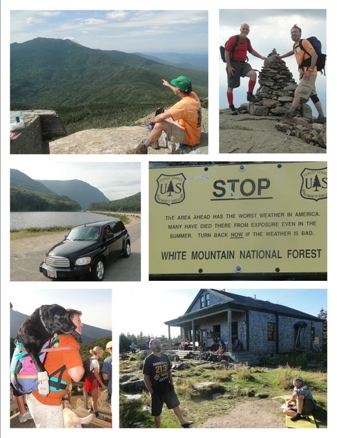
The only hitch in this obvious plan was that, once we descend the necessary 3000 feet, we must hitch 20 miles back to our rental car (see photo below), then drive another 30 minutes to Littleton. But that’s getting the cart (or car) before the horse (Brother Bill): Bill’s trick knee blows out during this descent. Lame with a familiar ligament injury, he knows to lurch and lock his right knee (as if splinted) to go down the stair-cased, rock-strewn path first, followed by the left knee carrying his full weight. Both ambitious hikers are now the walking wounded.
As we spill into the trailhead parking lot, the twice-daily AMC shuttle pulls up. The ordeal that began up on the ridge six hours ago, we finish with a minute to spare—“divine intervention,” we call it. (With hindsight, we see this whole incident as divine intervention. Had the injury not occurred and had we been allowed to progress toward the next hut as planned—through 24 more hours of rain, 11 more miles up and over three more mountains—we surely would have arrived cold, wet, and late—hours after supper.)
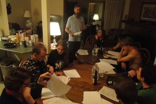
At the hospital, the ER docs waste no time in taking my ring finger and cutting it off—the wedding ring, not my finger. Pink is my new favorite color, as it returns life to my flesh. Scary good feeling. Pain relief pills are purchased for me, but Bill snarfs them instead. Our trail-turned-trial is not over. After so many spills and pills, it’s time for thrills on the hills. Forced to rest, get well and dry out, the next morning we pick up almost where we left off. We intrepid hikers work the plan. And the plan works!
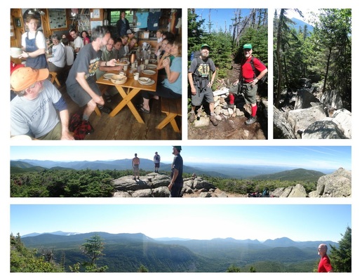
We climb several 4000-foot peaks, as three days of sunshine replace two days of rain. What a thrilling turn-around!—with 100+ miles visibility and 360-degree panoramic views (see photos above of Presidential Range and Franconia Range), instead of the 50-feet, cairn-to-cairn, eyes-to-the-ground fog. A full day of sunshine—this is all Bill wants for his birthday (celebrated with fellow hikers at Zealand Falls Hut; see upper left photo, above). God grants him that wish three times over.
We reach the Madison Hut, where we get hot soup, cold ice and a cardboard splint. My disjointed finger swells ominously, turning bluish-pink. Could the ring be cutting off blood flow? To save the finger, we’re told to head down the mountain quickly, via the Valley Way trail (see map above), with the Littleton hospital our only goal.
The only hitch in this obvious plan was that, once we descend the necessary 3000 feet, we must hitch 20 miles back to our rental car (see photo below), then drive another 30 minutes to Littleton. But that’s getting the cart (or car) before the horse (Brother Bill): Bill’s trick knee blows out during this descent. Lame with a familiar ligament injury, he knows to lurch and lock his right knee (as if splinted) to go down the stair-cased, rock-strewn path first, followed by the left knee carrying his full weight. Both ambitious hikers are now the walking wounded.
As we spill into the trailhead parking lot, the twice-daily AMC shuttle pulls up. The ordeal that began up on the ridge six hours ago, we finish with a minute to spare—“divine intervention,” we call it. (With hindsight, we see this whole incident as divine intervention. Had the injury not occurred and had we been allowed to progress toward the next hut as planned—through 24 more hours of rain, 11 more miles up and over three more mountains—we surely would have arrived cold, wet, and late—hours after supper.)
At the hospital, the ER docs waste no time in taking my ring finger and cutting it off—the wedding ring, not my finger. Pink is my new favorite color, as it returns life to my flesh. Scary good feeling. Pain relief pills are purchased for me, but Bill snarfs them instead. Our trail-turned-trial is not over. After so many spills and pills, it’s time for thrills on the hills. Forced to rest, get well and dry out, the next morning we pick up almost where we left off. We intrepid hikers work the plan. And the plan works!
We climb several 4000-foot peaks, as three days of sunshine replace two days of rain. What a thrilling turn-around!—with 100+ miles visibility and 360-degree panoramic views (see photos above of Presidential Range and Franconia Range), instead of the 50-feet, cairn-to-cairn, eyes-to-the-ground fog. A full day of sunshine—this is all Bill wants for his birthday (celebrated with fellow hikers at Zealand Falls Hut; see upper left photo, above). God grants him that wish three times over.
The three sunny days bring dozens of “through hikers” to the ridges of NH going north-bound (Georgia to Maine, or 2159 miles in 6 months). What long beards they have…. What diverse stories…. What compassion for canine companions….
(Two hikers restore a sick dog abandoned along the AT in PA, then bring it to NH, fulfilling destiny for both canine and human. Just the opposite can be as revealing and compelling a story: Mac, a 9-year-old, 90-pound chocolate Labrador refuses to go any farther, thus curtailing the family’s trek up Mt Lafayette and beyond. Rather than a scold for failing as “man’s best friend,” this troubled dog receives the royal treatment—harnessed onto the back of dad, who thus carries Big Mac three miles back down the mountain. See photo at left, lower left corner.)
And what interesting nicknames or handles these through hikers give one another: Happy Pappy (pictured above, lower right corner; he's a senior minister, our age, doing the whole AT trek for his 6-month sabbatical!), Glide, Stretch, Stroller, Bear & Bait (mother & daughter), Low Expectations & Metric (from Canada), Fiber (ate a whole box of it in one sitting), Hover (so as to balance on rocks), Muffin Man, Art Gypsy, Old Granddad, Pink Floyd (hiking in pink flip-flops), Lady Pants (hiking in a flouncy skirt), Sleep Tight, Gimley, Spud & Tater Tot (both from Idaho), and Veto (who kept refusing all other names). Of course, I query them for info helpful to other AT trekkers and me, should I ever work at REI.
Considering our trail-turned-trial, what would our handle be, if given one? Why, “Thrills” and “Spills,” naturally.

 RSS Feed